Download Shapefile data for the whole world : river basin and lake

Link info : https://bit.ly/307JC9o
###### SUBSCRIBE AND SHARE ######
WEB Site : https://www.learngeom.com
FACEBOOK Page : / elbouhali.geo
YOUTUBE Channel : / learngeomatics
Download Shapefile data for the whole world : river, basin, sub basin and lake
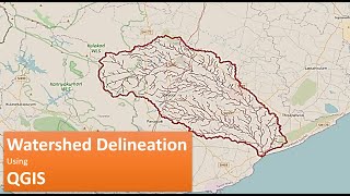
watershed delineation, download global basins, download global lacke, download global river, download global rivers. hydrographic networks for Africa, river Shapefile, watershed analysis, hydrographic networks for Asia, hydrographic networks for Australia, hydrographic networks for Europe, hydrological modeling, hydrographic networks for North America, river network, hydrographic networks for South America, download global watershed, hydrological data, river Shapefile, free shapefile data, download lacke polygons
HydroBASINS
Download global basins and sub basins / watershed and subwatersheds. Download basins and sub basins / watershed and subwatersheds for Africa. Download basins and sub basins / watershed and subwatersheds for Arctic. Download basins and sub basins / watershed and subwatersheds for Asia. Download basins and sub basins / watershed and subwatersheds for Australia. Download basins and sub basins / watershed and subwatersheds for Europe. Download basins and sub basins / watershed and subwatersheds for Greenland. Download basins and sub basins / watershed and subwatersheds for North America. Download basins and sub basins / watershed and subwatersheds for South America. Download basins and sub basins / watershed and subwatersheds for Siberia.
HydroRIVERS
The data can be downloaded in 2 different formats; Geodatabase or Shapefile and either as a global or regional coverage. Download global rivers / hydrographic networks data. Download rivers / hydrographic networks data for Africa. Download rivers / hydrographic networks data for Arctic. Download rivers / hydrographic networks data for Asia. Download rivers / hydrographic networks data for Australia. Download rivers / hydrographic networks data for Europe. Download rivers / hydrographic networks data for Greenland. Download rivers / hydrographic networks data America. Download rivers / hydrographic networks for South America. Download rivers / hydrographic networks for Siberia.
HydroLAKES
The data can be downloaded in 4 different formats :
1) Lake polygons (including all attributes) : ESRI Geodatabase. 2) Lake pour points (including all attributes) : ESRI Geodatabase. 3) Lake polygons (including all attributes) : Shapefile. 4) Lake pour points (including all attributes) : Shapefile.
River, Basin, sub basin shapefiles for any area of the world
River, Basin, sub basin shapefiles for any area of the world
how to download basin
Download Water body data (Shapefile) Lakes, River, Wetland of any Location
How to download river shapefile for any area
Download World River Basins, Lakes and Rivers Shapefile
How to download shapefiles of major basins, subcatchments, rivers, and lakes
Download basin, sub basin and river shapefiles for whole world
Creating Shapefile and Study Area Map for any Location
Download Free Basin, Subbasin, River shapefiles
Download Water Body Data (Lakes, River, Wetland) Shapefile
How to download hydrological Shapefiles from Hydrosheds
Download rivers and basins of any location
Download Basin, Watershed Boundary and River shapefile from HydroSHEDS
Download Water bodies from HydroSHEDS, Global Shapefile