Download very High Resolution u0026 Historical satellite images from Google Earth Pro

Highresolution imagery can be used for many purposes, including digital and print maps, backgrounds for drawings, or perspective images of the new 3D imagery.
Old images are mainly used to detect changes over time for a particular region. Based on your requirements and accuracy level, you can get old satellite imagery using several platforms, including Google Earth.
Google Earth Pro is a commercialoriented upgrade to Google Earth that offers additional features such as GIS data imports and advanced printing and saving modules.
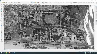
One way to download Highresolution and Historical images is Google Earth Pro. Google Earth Pro can now be downloaded for free, which enables saving and printing of highresolution images up to 4,800 x 4,800 pixels.
_____________________
This tutorial has demonstrated the process of downloading highresolution images and historical images through the use of Google Earth Pro.
____________________________________________________________
Google Earth Pro Complete Tutorial | Google Earth Pro For Beginners
✅ • Google Earth Pro Complete Tutorial | ...
How to add the latest Google Earth images to ArcGIS directly
✅ • How to add the latest Google Earth im...
____________________________________________________________
Check it out:
Like & Share the video with others:
✅ • Download very High Resolution & Histo...
_ _ _ _ _ _ _ _ _ _ _ _ _ _ _ _ _ _ _ _ _ _
Subscribe to our channel :
✅ / @rsgis6997
=========================================================
#GIS #GoogleEarth #GoogleEarthPro #Image #HighResolution