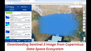
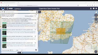
Downloading Sentinel 2 Image from Copernicus Data Space Ecosystem | Latest Updates

You will learn how to download sentinel2 images from Copernicus Data Space Ecosystem for free in this video. I hope this video will help you to enhance your knowledge in GIS and Remote Sensing even more. The Sentinel2 images are very essential and this video will help you to download the images for free.
Link: https://sentinels.copernicus.eu/web/s...
The Copernicus SENTINEL2 mission comprises a constellation of two polarorbiting satellites placed in the same sunsynchronous orbit, phased at 180° to each other. It aims at monitoring variability in land surface conditions, and its wide swath width (290 km) and high revisit time (10 days at the equator with one satellite, and 5 days with 2 satellites under cloudfree conditions which results in 23 days at midlatitudes) will support monitoring of Earth's surface changes.
SENTINEL2 is a European wideswath, highresolution, multispectral imaging mission. The full mission specification of the twin satellites flying in the same orbit but phased at 180°, is designed to give a high revisit frequency of 5 days at the Equator. SENTINEL2 carries an optical instrument payload that samples 13 spectral bands: four bands at 10 m, six bands at 20 m and three bands at 60 m spatial resolution. The orbital swath width is 290 km.
The twin satellites of SENTINEL2 provide continuity of SPOT and LANDSATtype image data, contribute to ongoing multispectral observations and benefit Copernicus services and applications such as land management, agriculture and forestry, disaster control, humanitarian relief operations, risk mapping and security concerns.
For more videos related to GIS, Remote Sensing, Geoinformation Science and Climate change please watch videos of @EARTHGISensing. Please do not forget to like, comment and subscribe to @EARTHGISensing
#download #sentinel2images #2024 #copernicus #data #space #ecosystem #satelliteimages #remotesensing #sentinel2datafromcopernicus #sentinel