Secret sauce that brings YouTube followers, views, likes

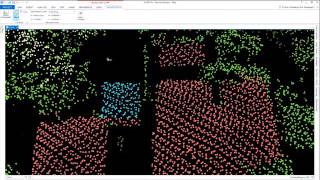
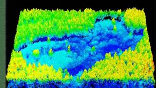
Downloading Using and Analyzing Lidar Data in ArcGIS Pro

Downloading Using and Analyzing Lidar Data in ArcGIS Pro. Includes obtaining and formatting data from NationalMap.Gov, loading it into Pro, and creating DEMs and raster files, creating bare earth vs 1st Return data sets, slope, aspect, contours, index contours, hillshade, checking projection information and metadata, trace downstream, adding data from ArcGIS Online and the Living Atlas of the World, using USGS topographic and hydrologic datasets, using the raster calculator, creating 2D and 3D scenes, and much more.


Recommended