Drainage Stream Density u0026 Drainage frequency of a basin using Arc-Gis.

This video explains how to use ARCGIS to determine
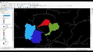
1) Stream density of a basin
2) drainage Frequency value of a basin
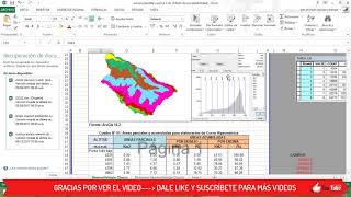
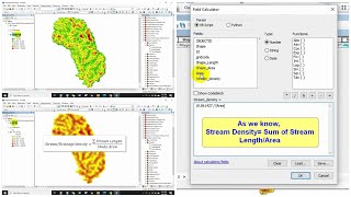
Drainage Density: Drainage density, defined as channel length per unit watershed area (km/km2), reveals the amount (or density) of channels in a watershed.
Drainage density can also affect the shape of a river's hydro graph during a rain storm
Factors affecting drainage density include geology and density of vegetation. The vegetation density influenced drainage density by binding the surface layer, thus preventing overland flow from concentrating along definite lines and from eroding small rills which might become small channels.
Importance of Studying Stream/Drainage Density
1)Stream density is an important watershed characteristic that
can be an indicator of potential water supply.
2)Stream Density, can be used to compare
opportunities for recreation and water supply in different
watersheds. Watersheds with high stream density provide
more opportunities for birding, boating, fishing, swimming,
and hunting. High stream density is also indicative of the
potential for plentiful water supply.