Drone 2D Mapping Post Processing - Complete Tutorial

Claim Your FREE GUIDEBOOK to Using Drones in Construction
https://bit.ly/42MY2b9
In this video, we take a deep dive into Drone 2D Mapping and PostProcessing. We start off with a detailed explanation of how to capture drone maps, working with data uploads, and move on to a comprehensive look at the map tools all the way through to exporting your data using the reports available. For viewers who are interested in jumping to a specific part of the video we have created individual chapters below, just click on the time marks to see the content for each chapter.
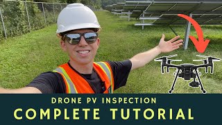
DroneDeploy software has mapped over 200 million acres on 400,000 different job sites and their stated mission is to “make the skies open and accessible for everyone.” Their business consists of data capture, analysis of the data, and then processing the data to output asset reports for their customers. The platform is great for companies of any size and allows them to improve their workflow through data storage, scalable image processing, and shareable realtime drone maps and 3D models.
The Drone Life has extensive experience creating aerial maps for construction, environmental, and renewable industries. We work with general contractors, developers, and investment firms to create unique asset reports from data collected by drone flights. We have an expert team of highly qualified licensed professionals ready to document your very own project. To speak to an expert today visit https://thedronelifenj.com'>https://thedronelifenj.com
►Resources
➡ Start Your FREE 14Day DroneDeploy Trial Now http://bit.ly/3EPADdN
(Video) Drone Mapping for Construction: Complete Guide • Drone Mapping for Construction: Compl...
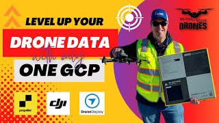
(Article) Drone GCPs: Do You Need Them, How They Work, and Which Ones to Buy https://thedronelifenj.com'>https://thedronelifenj.com/dronegrou...
DroneDeploy Support Docs https://help.dronedeploy.com/hc/enus
►Equipment Used in this Video
Mavic 2 Pro Drone https://amzn.to/3C62yom
►Our MustHave Drone Equipment Checklist
✅ Budget Friendly Ground Control Points (GCPs) http://bit.ly/3nAT2pH
✅ Most Reliable SD Card for Drone Mapping http://bit.ly/3lZOhWn
✅ Heavy Duty Landing Pad http://bit.ly/3zt1hXA
✅ Collapsable Orange Safety Cones http://bit.ly/40Tr2fp
✅ OSHA Certified Safety Vest http://bit.ly/3KsycSt
✅ Wind Speed Anemometer Gauge http://bit.ly/3ZCaYO5
✅ Best Flight Planning Tablet http://bit.ly/40Dci4q
✅ Handheld VHF Airband Transceiver http://bit.ly/40AyLPP
►About The Drone Life
The Drone Life is an industryleading UAS service provider that provides turnkey aerial data solutions nationwide. We proudly specialize in the industrial, environmental, renewable, and construction industries. Our team consists of highly experienced, dependable, and licensed drone professionals that are committed to safety, quality, and customer success.
Website https://thedronelifenj.com'>https://thedronelifenj.com
LinkedIn / thedronelifenj
Instagram / thedronelifenj
Facebook / thedronelifenj
TikTok / thedronelifenj
►Chapters
Intro 0:00
Capturing the Map 1:10
Mobile Upload 4:18
DroneDeploy Free Trial Signup 10:06
Legacy Uploader 10:53
Smart Uploader 16:49
Uploading Large Data Sets 20:20
Upload Existing Map 21:34
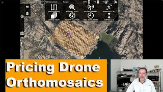
Map Tools 22:24
Annotations 27:23
Layers 27:54
Uploading Additional Images 30:44
Calibration Marker 32:25
Cropping the Map 34:14
Resolution 34:49
Alignment 35:19
Accuracy 36:08
3D Map Viewer 37:24
Exports 38:26
Sharing the Data 44:10
Outro 47:05
#dronemapping #dronesoftware #dronedeploy