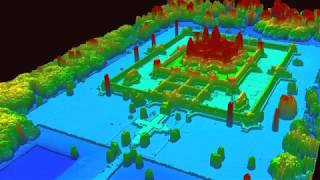
Drone + LiDAR

The Riegl RiCOPTER is a robust platform capable of 30 minute flight times with a full sensor payload (VUXSYS). This video highlights a corridor survey of a 3mile US Army Corp of Engineers levee project. All data was captured and processed inhouse. This allows for a quick turnaround time and reduces the risk of data compromise.
Equipment Used:
CSI Riegl RiCOPTER
VUXSYS VUX1UAV, 2x Sony A6000 Cameras, AP20 IMU
Processing:
RiPROCESS, Global Mapper, ArcGIS
Chustz Surveying, LLC is based in the USA and provides hydrographic surveying, GPS surveying, singlebeam technology, multibeam technology and LiDAR (Light Detection And Ranging) acquisition
For more information:
https://www.chustzsurveying.com
211 Richey St.
New Roads, Louisiana 70760
(225) 6385949