Earthquakes of Alaska: 1918 - 2019

The M7.1 earthquake that occurred under Anchorage, Alaska, on November 30, 2018, was the largest earthquake to impact the city in 54 years. It was not, however, the largest recorded earthquake there. That distinction goes to the March 28, 1964, M9.2 Great Alaskan Earthquake (a.k.a. the Good Friday Earthquake) that struck the region as the largest earthquake ever recorded in North America, and the secondlargest earthquake recorded anywhere. It in fact released more than 1000 times as much energy as the 2018 earthquake and generated a devastating tsunami.
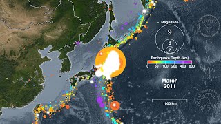
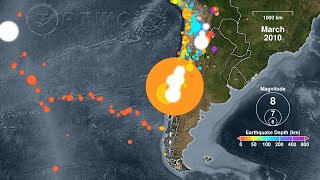
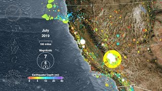
Alaska and its Aleutian Islands lie above a tectonic plate boundary called a “subduction zone” where the Pacific Plate grinds beneath the North American Plate. This type of plate boundary can create volcanoes, such as those that make up the Aleutian Islands that stretch from Kamchatka, Russia to the Alaska Peninsula. Subduction zones can also produce megathrust earthquakes with large vertical motions that cause devastating tsunamis. Alaska and the Aleutian Islands have been the source of many such earthquakes and tsunamis in the more than 100 years of scientific measurement of these phenomena, and this animation shows all of the recorded seismic activity in this region from 100 years before the 2018 Anchorage earthquake up until the present day*
Some significant earthquakes shown in this animation include:
April 1, 1946 M8.6 Unimak Island, Aluetian Is. (damaging/deadly tsunami)
Aug 22, 1949 M8.0 Haida Gwaii (Queen Charlotte Island), Canada (tsunami)
Nov 4, 1952 M9.0 Kamchatka, Russia (damaging/deadly tsunami)
Mar 3, 1957 M8.6 Andreanof Islands, Aleutian Islands (damaging tsunami)
Jul 10, 1958 M7.8 Southeastern Alaska (Lituya Bay rockfall and megatsunami)
Mar 28, 1964 M9.2 Prince William Sound (damaging/deadly tsunami)
Feb 2, 1965 M8.7 Rat Islands, Aleutian Is. (damaging tsunami)
Nov 3, 2002 M7.9 Central Alaska (Denali Fault)
Oct 28, 2012 M7.8 Haida Gwaii (Queen Charlotte Island), Canada (tsunami)
May 24, 2013 M8.3 Sea of Okhotsk (very deep: 598 km / 372 mi.)
Jan 23, 2018 M7.9 southeast of Kodiak Island
Nov 30, 2018 M7.1 Anchorage (significant damage, no deaths)
The U.S. Pacific Tsunami Warning Center (PTWC) and the U.S. National Tsunami Warning Center (NTWC) will issue tsunami alerts for any potentially tsunamicausing earthquake in the Alaska region. These alerts will be posted to:
https://tsunami.gov
To see a comparison of the relative sizes of some historic earthquakes, please watch:
• Perspective: a graphical comparison o...
To see how subduction zones make tsunamis, please watch:
• How to Make a Tsunami
Earthquake Data Source: United States Geological Survey (USGS)/National Earthquake Information Center (NEIC) searchable catalog:
https://earthquake.usgs.gov/earthquak...
*Please note that this animation shows every earthquake in the USGS/NEIC catalog for this region. As the animation moves forward in time so too does the science of seismology with the continual addition of newer and better instruments. As the animation approaches the present day these instrument networks are able to detect smaller and smaller earthquakes, creating the illusion of increasing activity. This effect is especially noticeable in 1973 and again in 2002. In reality these smaller earthquakes have always occurred, but the technology has only recently been able to detect them.