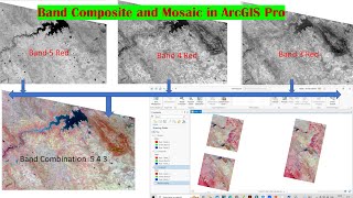
Easy Landsat 9 Band Combination and Pansharpening with Blend Modes

The shiny new Landsat 9 earth imaging satellite is now live and beaming down glorious data to us. Here's how to grab fresh Landsat layers and merge the bands together into a full color composite, and also how to do a megaeasy version of pansharpening with the higher resolution panchromatic band, in ArcGIS Pro.
Check this blog post for some more background and a list of the steps: https://www.esri.com/arcgisblog/prod...
Download the latest Landsat 9 data: https://earthexplorer.usgs.gov/
Learn more about the available bands: https://www.usgs.gov/faqs/whatareba...
Thanks to Joshua Stevens for his help: https://www.joshuastevens.net/
Learn from The Captain about how weird (and imaginary) color is, and how we process electromagnetic wavelengths and interpret them in our brains as colors: • CD / Color
Check out some other social channels where I share howto's and updates on random map adventures:
http://adventuresinmapping.com
https://www.esri.com/arcgisblog/auth...
/ john_m_nelson
/ johnmnelson
/ johnmnelson