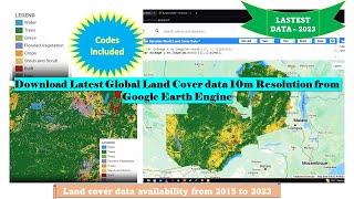
ESA releases global land cover map for 2020 at 10-m resolution

The European Space Agency (ESA) WorldCover 10 m 2020 product provides a global land cover map for 2020 at 10 m resolution based on Sentinel1 and Sentinel2 data. The WorldCover product comes with 11 land cover classes and has been generated in the framework of the ESA WorldCover project, part of the 5th Earth Observation Envelope Programme (EOEP5) of the European Space Agency.
Link to GEE Data Catalog: https://developers.google.com/earthe...
Link to GEE code for comparing Esri 10m global land cover and ESA 10m global land cover
https://code.earthengine.google.com/4...
Cdoe credits to David Loaiza: / 1451241083632070661
leafmap homepage: https://leafmap.org
geemap homepage: https://geemap.org
GitHub: https://github.com/giswqs/geemap
Twitter: / giswqs
YouTube channel: / qiushengwu
GEE Tutorials Playlist: https://gishub.org/youtubegee
Leafmap Tutorials Playlist: https://gishub.org/youtubeleafmap
Geographic Software Design Playlist: https://gishub.org/gsd
Spatial Data Management Playlist: https://gishub.org/sdm