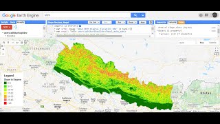
Esri 10-meter LULC in Google Earth Engine

ESRI 10meter 2020 Global Land Use Land Cover from Sentinel2:
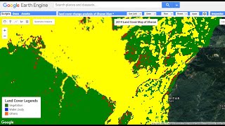
This layer displays a global map of land use/land cover (LULC). The map is derived from ESA Sentinel2 imagery at 10m resolution. It is a composite of LULC predictions for 10 classes throughout the year in order to generate a representative snapshot of 2020. This map was produced using machine learning by Impact Observatory for Esri. © 2021 Esri.
Processing platform Sentinel2 L2A/B data was accessed via Microsoft’s Planetary Computer and scaled using Microsoft Azure Batch.
The output provides a 10class map of the surface, including Water Areas, Trees, Grass, Flooded vegetation, Crops, Scrub/shrub, Built Area, Bare ground, Snow/Ice, and Clouds.
Sample Code:
https://code.earthengine.google.com/c...
Script Link: https://drive.google.com/file/d/1jPVw...
Earth Engine Snippet:
esri_lulc2020= ee.ImageCollection("projects/satio/opendatasets/landcover/ESRI_GlobalLULC_10m")
ESRI: https://livingatlas.arcgis.com/landcover