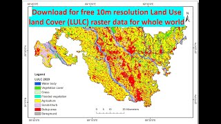
ESRI 2020 Land Use land Cover (LULC) Map - How to Download Clip u0026 Map | Remote Sensing Tutorial

Esri's #esri highresolution (10meter), 2020 global land cover map was built using the European Space Agency (ESA) Sentinel2 satellite imagery. Remote Sensing Tutorial
Background Music "After Midnight" arranged by Moges Y.
GeoViz Plus #GeoVizPlus covers some, but not limited to GIS Tutorial, Remote Sensing practical lessons, GIS Beginner, GIS Intermediate, Image Analysis, LULC, Map Tricks
#GIS #Geospatial #RemoteSensing #Photogrammetry #ArcGIS #ErdasImagine #QGIS
/ @geovizplus
An area in #Ethiopia is used to demonstrate the usage of ESRI 2020 LULC data.
0:00 Introduction
0:06 How to utilize ESRI 2020 LULC
0:54 Download Tiff Files
1:56 Clipping the AOI
3:22 Vectorizing the raster LULC image
6:36 Use Excel to manipulate the data
7:55 Create LULC Map (Map layout)