The easiest way to skyrocket your YouTube subscribers

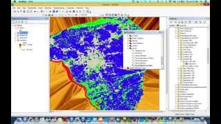
ESRI ArcGIS : Zonal Statistics || How to Extract Elevation using DEM and Boundary Shp File

Zonal Statistics tool is a statistic function to calculate zone dataset, based on values from another dataset (a value raster). A single output value is computed for every zone in the input zone dataset.
If you enjoyed the video, do hit the Like button and Subscribe to my channel,
don't forget to Share with your friends and family.
SOCIAL MEDIA LINK
Follow me on Instagram and Twitter for more updates and photos:
Instagram ID: / anujinstapage
Twitter ID: / anujtiwaritweet
Email for the questions, suggestions and business inquiries: [email protected]


Recommended