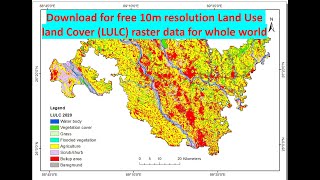
ESRI Latest Land Cover Data 10 m Resolution Released on 24 June 2021

Hi everyone, welcome again in GIS and RS Solution Channel. Today’s tutorial is very special for those who are looking for land cover map for a particular area or the whole globe. ESRI and Impact Observatory institute released 10meter resolution global land cover data set. In this video I will show you how you can download this 10 m resolution land cover data set for free and how you can prepare land cover map for your area of interest in ArcGIS. Then let’s start.
Esri Releases New 2020 Global Land Cover Map
Website link: https://livingatlas.arcgis.com/landco...
Credits (Attribution)
This dataset was produced by Impact Observatory for Esri. © 2021 Esri. This dataset is available under a Creative Commons BY4.0 license and any copy of or work based on this dataset requires the following attribution: This dataset is based on the dataset produced for the Dynamic World Project by National Geographic Society in partnership with Google and the World Resources Institute.