Esri UC 2015 - Analysis and Geoprocessing in ArcGIS Pro

This presentation from the 2015 Esri User Conference explains new spatial analysis and geoprocessing capabilities and tools in ArcGIS Pro. Analysis transforms raw data into information or knowledge, and by extension, spatial analysis does this for geographic or spatial data. While visualizing data is useful, analyzing it is what can begin to solve problems and enable decisionmaking. Geoprocessing is the technology that makes spatial analytics possible.
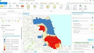
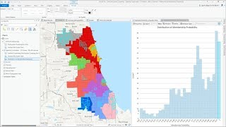
ArcGIS Pro runs on a scalable 64bit architecture, capable of complex analyses. It extends from 2D into 3D and even 4D (temporal) analysis. There are a number of extensions available for ArcGIS Pro. Learn more about Spatial Analyst, Network Analyst, 3D Analyst, and Geostatistical Analyst. See how to accomplish an analysis in ArcGIS Pro.
Included in the presentation are live demos and walkthroughs of ModelBuilder, how to accomplish an analysis in ArcGIS Pro, and how to create a geoprocessing workflow. We also cover a migration story to show how users can switch from ArcMap to ArcGIS Pro.
ArcGIS Pro: https://www.esri.com/enus/arcgis/pro...
ArcGIS Geostatistical Analyst: http://www.esri.com/software/arcgis/e...
ArcGIS Spatial Analyst: http://www.esri.com/software/arcgis/e...