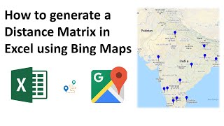
Excel - Calculate the Distance Between Two Locations and Show on a Map

In this video I show you how to calculate the distance between 2 cities anywhere in the world. My solution...
1. Converts the textbased city names to Geographical data types
2. Calculates the longitude and latitude values for the cities
3. Calculates the distance in miles between the 2 cities
4. Plots the cities on a map with a heading showing the city names and the distance
For full details see the timestamps below:
⏱ Timestamps
00:00:00 Introduction
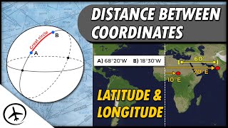
00:01:51 What are Longitude and Latitude?
00:02:49 Convert text data to geographic data
00:03:33 Calculate Longitude and Latitude values
00:04:32 Calculate the distance between the cities
00:05:05 Create the map
00:07:41 Add location pins to the map
00:08:39 Create the heading by concatenating values
Notes and Resources
Download a copy of the file used in this video: https://share.getcloudapp.com/eDuneQ72
The formulas that I used in the demos:
=INT(ACOS(COS(RADIANS(90B4)) * COS(RADIANS(90B5)) + SIN(RADIANS(90B4)) * SIN(RADIANS(90B5)) * COS(RADIANS(C4C5))) * 3959)
=VALUETOTEXT(A4) & " " & VALUETOTEXT(A5) & ": " & CHAR(10) & B7 & " Miles"
✅ Want more FREE training?
Why not check out my other tutorials and/or subscribe to my newsletter, both of which can be done at https://theexceltrainer.co.uk
♂ Let's connect on social
Twitter: / theexceltrainer
Facebook: / theexceltrainer
LinkedIn: / thomasmik
#excel #map #distance