Export Coordinates of Vertices from a Polygon Shapefile using QGIS

In this QGIS tutorial, we'll show you how to export the coordinates of vertices from a polygon shapefile. Whether you're working on geographic analysis, data visualization, or simply need to extract spatial data, this stepbystep guide will help you harness the power of QGIS, a powerful opensource GIS software.
Additional Resources
QGIS Download: https://www.qgis.org/en/site/forusers...
Prerequisites
Before we begin, make sure you have QGIS installed on your computer. You can download it for free from the official QGIS website (link provided above).
StepbyStep Guide
Launch QGIS: Open QGIS on your computer.
Load/Create Your Shapefile: Use the "Add Vector Layer" tool to load your polygon shapefile into QGIS. Or make a polygon in temporary layer
Enable the Vertex Tool: Click on the "Toggle Editing" button in the toolbar, then select the polygon layer you want to work with.
Select a Polygon: Click on the polygon you want to extract vertex coordinates from. It should now be highlighted.
Access Vertex Coordinates: Click on the "Vertex Tool" in the toolbar. This will allow you to interact with the vertices of your polygon.
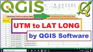
Change attributes table: Rightclick on the layer and make changes in attributes. Apply expression to update lat long values.
Customize Export Options: In the new layer, rightclick and choose "Save As." Select the format as CSV and configure any additional export options you need. During export choose projection system as UTM and geometry as XY.
Save the CSV File: Choose a location to save your CSV file, and click "Save."
Import Data into Excel: Open your CSV file in a spreadsheet software like Microsoft Excel to view and work with the extracted coordinates.
By following these steps, you'll be able to export vertex coordinates from a polygon shapefile using QGIS. This valuable skill can be applied to various GIS and spatial data analysis projects.
Don't forget to like, share, and subscribe for more QGIS tutorials and geospatial tips. If you found this video helpful, please leave a comment and let us know what other QGIS topics you'd like to learn about. Thanks for watching! #QGIS #GIS #Geospatial #Shapefile #Tutorial #Mapping #Coordinates #DataExport