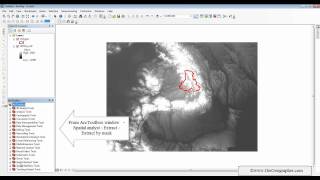
Extract by Polygon Tool ArcGIS

Extract by Polygon Tool, Extraction Toolset, Spatial Analyst ArcToolbox
summary
Extracts the cells of a raster based on a polygon by specifying the polygon's vertices.
Usage
Additional attributes from the input raster, if any, will be carried over asis to the output raster attribute table. Depending on the nature of the property being recorded, some of the attribute values may need to be recalculated.
When a multiband raster is specified as the Input Raster (in_raster in Python), all bands will be used.
To process a selection of bands from a multiband raster, first create a new raster dataset composed of those particular bands with the Composite Bands tool, and use the result as the Input Raster (in_raster in Python).
The default output format is a geodatabase raster. If an Esri Grid stack is specified as the output format, note that the name cannot start with a number, use spaces, or be more than nine characters in length.
To extract based on a polygon in a feature class instead of providing a series of x,y pairs, you can use the Extract By Mask tool.
The polygon object may consist of just one part, or many parts as a polygon class. In the later case, all polygon parts must be contiguous, such that they could be outlined by one polygon. To extract based on a polygon feature that contains multiple disconnected parts, use the Extract By Mask tool.
The center of the cell is used to determine whether a cell is inside or outside a polygon. If the center is within the arcs of the polygon, the cell is considered fully inside, even if portions of the cell fall outside the polygon.
The polygon has a limit of 1,000 vertices. Polygon vertices must be entered in a clockwise order. The first and last vertex should be the same to close the polygon. This is especially important if multiple polygons are used. In that case, if the last point for each individual polygon is not identical to its starting vertex, the polygons may be closed automatically by directly connecting to the first vertex. However, this may produce a different result from what you may have expected, so take care if using this technique.
The arcs of the polygon can cross one another, but convoluted polygons are not recommended.
Cell locations that are not selected are assigned a value of NoData.
If the input raster is integer, the output raster will be integer. If the input is a floating point, the output will be a floating point.
See Analysis environments and Spatial Analyst for additional details on the geoprocessing environments that apply to this tool.
polygon ,extract by polygon ,extract ,clip raster file with polygon vs extract raster by mask ,extract small portion of polygon ,extract by rectangel ,clip raster by polygon in arcgis ,arcgis extract raster by mask ,how to clip raster by polygon ,extract by multi values to point ,cut polygon ,polygons ,extracting polygon ,area of polygon ,arcgis clip raster file with polygon ,trace polygon ,tracing polygon ,clip or split shp data by attribute and polygon
Explanation of the tool:
https://gisforwe.blogspot.com/2022/01...
Follow the GISforWE website here:
https://bit.ly/GISforWE
A site for anyone interested in the field of GIS from here:
https://gisforwe.blogspot.com/
Proficiency in dealing with geographic data through ArcGIS programs:
• احترف التفاعل مع البيانات من خلال برا...
Learn the basics of creating geodatabases from here:
• أساسيات بناء قواعد البيانات الجغرافية...
Here is a page and a group on Facebook to learn more about Geographic Information Systems (GIS) and ArcGIS programs through these links:
ArcGIS Facebook group:
/ 486795389231905
Facebook group GIS for WE ArcGIS:
/ esri.arcgis
GIS for WE Facebook page:
https://www.facebook.com/profile.php?...
Video link for an introduction to learning on ArcGIS programs in three stages:
• مقدمة دورة تعلم ArcGIS بثلاثة مراحل |...
#ArcGIS
#Analysis_GIS
#Data_Analysis
Prepared and presented by the developer and researcher in the field of geographic information systems, Hossam Jubeh
Ramallah Palestine.
#GISforWE
GIS for the World of ELearning