Extraction or Digitization of Land features using Landsat 8 Data || ArcMap 10.2.2 || @GeoTech Studio

#GeoTech_Studio
This video is about the extraction of land features from the Landsat Images.
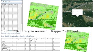
Mapping of natural resources like forest and water bodies using satellite imagery has gained much importance in the recent past. Both forest and water resources are subject to intense exploitation and monitoring them at regular intervals is imperative for their sustainable management. Water bodies, which play a key role in the global carbon cycle and climate variations, are mapped in spatiotemporal domain to analyze and assess the extent and rate of their degradation and disappearance. Geospatial tools are proving to be advantageous for such impact assessment for the implementation of conservation measures .
Researchers across the globe have used different satellite data varying in spatial, spectral, and temporal characteristics to generate thematic maps of land use land cover or maps with special emphasis on water bodies. At the same time, various techniques have been adopted to extract these features from satellite imagery and each method has its own merits and demerits.
Visual interpretation of satellite data provides the best delineation of water bodies of varied sizes but is time consuming, especially when working with high resolution data . The simple and common approach of unsupervised classification which uses an interactive selforganizing data analysis technique provides results with very low accuracy, when there is spectral overlap between water bodies with other classes. In contrast, supervised classification presents more accurate and reliable outputs than unsupervised method but may vary when used for high resolution data . Moreover, the supervised technique requires sufficiently large spectral training data sets and is not a fully automated method. Further it does not take into account the spatial features of the objects .
Follow us on Social Media:
Facebook IDs : / bhuwon.paudell
/ bhuwan.paudel.739
Facebook Page: / geotechstudio
Twitter id: / bhuwanpaudel96
instagram ids: / iambhuwanpaudel