Secret weapon how to promote your YouTube channel

Feature Extraction from Classified LiDAR Data

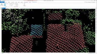
Following on from the reclassification theme in the previous video, in the fifth video presentation, we show how to automatically generate vector features from classified points. We show the process of extracting buildings as 3D polygons, trees as 3D points, and powerlines as 3D lines, and we visualize each of these in Global Mapper’s 3D View.
If you have questions about any of the workflows or topics covered in this presentation, email: [email protected].
For licensing or sales questions, email [email protected].
To download an evaluation copy of Global Mapper, visit: www.bluemarblegeo.com/products/globalmapper.php


Recommended