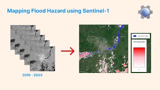
Flood Hazard Mapping in Earth Engine

Do you want to map the level of flood hazard in your region? Today my friend, you will find a way to do it in Google Earth Engine. I just made a script to do that.
Check it out: https://code.earthengine.google.com/9...
In the video, I am using distance from permanent water, elevation, topographic position index, vegetation, and wetness data to model the flood hazard in my birth city of Jambi. I am using scoring to evaluate the factor that determines the flood hazard. For example, the closer the area is to the river/permanent water, the higher the hazard score and vice versa. The result is a 5level flood hazard map from very low to very high.
Hope this video helps!
Email: [email protected]
Linkedin: / ramiqcom
GitHub: https://github.com/ramiqcom


![Rice Mapping using Sentinel 1, 2 in Earth Engine [GEE]](https://i.ytimg.com/vi/We9VoweOuhM/mqdefault.jpg)


![FULL COURSE Google Earth Engine Python API and Colab for Absolute Beginners in 3 Hours [2023]](https://i.ytimg.com/vi/Lqirs04EccA/mqdefault.jpg)