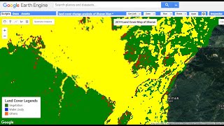
Flood Mapping Google Earth Engine Using Sentinel SAR Satellite Imagery

In this video, we explore the powerful capabilities of Google Earth Engine and Sentinel SAR dataset for flood mapping and assessment. Using remote sensing data and advanced techniques, we demonstrate how to quickly and accurately identify flooded areas, estimate flood extent and analyze flood dynamics over time.
We begin by introducing the basics of Sentinel SAR data and Google Earth Engine, and then move on to applying these tools for flood mapping and assessment. We showcase several examples of how these techniques have been used in realworld scenarios, such as during natural disasters and for environmental monitoring.
Our stepbystep guide will help you to gain a deeper understanding of how to use Google Earth Engine and Sentinel SAR data to analyze and visualize flood patterns. We also discuss the importance of accurate flood mapping and how it can help to mitigate the impact of floods on local communities.
Whether you are a researcher, student or someone interested in learning more about flood mapping and assessment, this video is a mustwatch. Join us on this journey as we uncover the potential of Google Earth Engine and Sentinel SAR data for flood analysis.
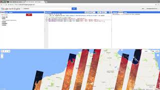
check comments for the Function code and links for feature boundary!!