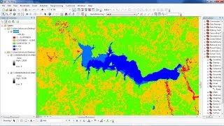
Forest Cover Classification using SVM in ArcGIS| Forest Cover Mapping| Identify Forest Type Class.

How to do Forest Cover Classification using Landsat Data in ArcGIS.
Karnataka Forest Type Classification In ArcGIS.
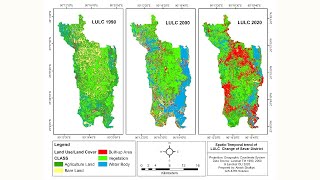
Forest Cover Classification using SVM in ArcGIS| Forest Cover Mapping| Forest Change Analysis. Satellite images used in forest cover classification. Modelling, mapping and monitoring of forest cover. Forest cover classification using Landsat ETM+ data. FOREST COVER CLASSIFICATION USING GEOSPATIAL Data. CLASSIFICATION OF FOREST AREA USING OPTICAL AND RADAR IMAGES. Supervised classification approach for assessment of forest.
Steps: ..................................................................
Forest Cover Classification using Landsat 8 Image.
In this Video Tutorial, We will Classified Forest Cover Into 4 Types.
1. Dense Forest (Dark Red + black shades of pixel showing )
2. Moderate Forest ( Light Red Pixel)
3. Open Forest (purple shades of pixels)
4. Scrub land (light brown with soil texture tone pixels)
* Point to Remember
1. I have already mask out NonForest Area using NDVI.
2. I am only working on Forest Layer which have been extracted by mask using NDVI.
Thank you.
You can ask anything about this tutorial, please feel free to contact me on my WhatsApp number 7529918160.
#Foresttypeclassification #ForestCoverMapping #SVMclassifier #ArcGIS #ForestClassification