YouTube doesn't want you know this subscribers secret

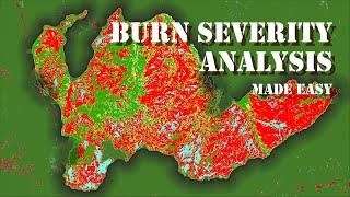
Forest fire assessment using indices and change detection tool in ArcGIS Pro

In this video you will see how to do forest fire assesment in ArcGIS Pro. First I explained BAI process which describe below.
"The Burn Area Index (BAI) uses the reflectance values in the red and NIR portion of the spectrum to identify the areas of the terrain affected by fire.
BAI = 1/((0.1 RED)^2 + (0.06 NIR)^2)
Red = pixel values from the red band
NIR = pixel values from the near infrared band
Another process which I showed that is using change detection wizard in ArcGIS PRo. Where from 2 different times image of before and after incidents you can directly identify change area with multiple bands indices technique.
#arcgispro #arcgis #forestfire #esri


Recommended