Forest TREE Cover % percentage with GIS and Remote Sensing u0026 GEE Learn Geography GIS RS with AI

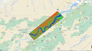
Forest cover is a vital component of our planet's ecosystems, and understanding its extent and distribution is crucial for environmental conservation and management. In this video, we'll be focusing on the East Khasi Hills region as our study area. First off, we're utilizing data from the MODIS satellite to obtain imagery of the area. By clipping this imagery to our region of interest using GIS techniques, we can isolate the data relevant to the East Khasi Hills.
Now, let's talk visualization. We've set up a vibrant color palette to represent the percentage of tree cover in our region, ranging from lush green for dense forests to lighter shades for lesser coverage. This visualization not only makes the data more visually appealing but also aids in interpretation.
To better understand the forest cover, we're calculating statistics such as the mean tree cover percentage. This allows us to quantify the extent of forested areas in our region. And there you have it, folks! Through the power of GIS, remote sensing, and a sprinkle of AI, we've gained valuable insights into forest cover dynamics in the East Khasi Hills region.
I hope you found this video informative and insightful. If you did, don't forget to give it a thumbs up and share it with your fellow geography enthusiasts. And remember, if you have any questions or suggestions for future topics, feel free to drop them in the comments below.
Thanks for joining me today on Learn Geography GIS RS with AI. Until next time, keep exploring, keep learning, and I'll see you in the next video. Happy mapping!