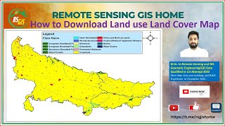
Free Download ESRI Latest Land Use Land Cover (LULC) 10m Resolution Data from 2017 to 2022

Hello, In this video we will learn how to download ESRI Latest Land Use Land Cover (LULC) 10m Resolution Sentinel 2 Data from 2017 to 2022. Therefore, those who are looking for land cover map for a certain area or the entire globe. The 10 meter resolution global land cover data set was provided by Impact Observatory Institute and ESRI. You can create land cover map in arcgis with these free satellite images.
✨Website Link: https://livingatlas.arcgis.com/landco...
========================================
Chapters:
00:00 Introduction
01:20 Data Download Process
05:00 Land Cover Mapping in ArcGIS
========================================
✨Facebook: / gisandremotesensingeducation
✨LinkedIn: / gisrseducation
========================================
▶ Citation:
Karra, Kontgis, et al. “Global land use/land cover with Sentinel2 and deep learning.” IGARSS 20212021 IEEE International Geoscience and Remote Sensing Symposium. IEEE, 2021.
▶ Acknowledgements:
Training data for this project makes use of the National Geographic Society Dynamic World training dataset, produced for the Dynamic World Project by National Geographic Society in partnership with Google and the World Resources Institute.
========================================
Related Queries:
Esri latest land use land cover download
Esri latest land use land cover 2020
esri land use/land cover download
esri land cover
esri 10m land cover download
esri land cover 10m
esri land cover data
esri land cover legend
========================================
#esri #sentinel #arcgis