Geologic Interrogation of Photogrammetric Outcrop Reconstructions: Uncertainty and Mitigation

Speaker: Adam J. Cawood, Ph. D., Senior Research Scientist, Southwest Research Institute
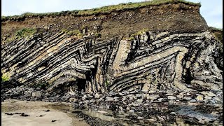
Highresolution 3D outcrop reconstructions are now routinely used to supplement geoscience field investigations. Sources of reconstruction error are addressed extensively in existing literature, and data acquisition and processing protocols required to ensure the accuracy, precision, and fidelity of 3D reconstructions are well established. Less wellconstrained is how the methods chosen for interrogating 3D reconstructions can impact final analyses. Here we show that visualization techniques, data extraction choices, and geologic interpretation strategies may substantially impact results derived from outcrop reconstructions. We present a series of geologic fold, fault, and fracture analysis case studies that illustrate the effects of different data interrogation methods on final results. Recommendations for accurate and effective digital outcrop analysis are provided in the context of ensuring data reliability, quantifying uncertainty, and maximizing measurement reproducibility.
We explore alternative approaches to visualizing outcrop reconstructions, showing the relative merits of each approach. For example, false color schemes derived from geometric attributes (e.g., dip magnitude, dip direction) provide powerful tools for enhancing the interpretation of 3D geologic features. Comparisons of different methods to extract surface orientations from outcrop reconstructions yield recommendations for reproducibility and uncertainty quantification. Outcrop interpretation strategies are addressed, with reference to established workflows in geophysical datasets and emphasis on scenario testing and exploration of alternate interpretations. Data projection, cleaning and smoothing of polyline interpretations, and strategies for effectively transferring data from 3D to 2D are considered, with focus on fidelity retention, appropriate subsampling strategies, and geometric artefact avoidance. Finally, we discuss the importance of complimentary datasets (e.g., from traditional fieldwork and laboratory analysis) and demonstrate that an integrated approach to outcrop studies represents an improvement over conventional fieldbased or closerange remote sensing studies performed in isolation.