Grow your YouTube views, likes and subscribers for free

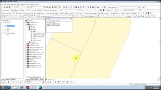
Geoprocessing in ArcGIS 10.x

Geoprocessing is a fundamental part of any GIS analysis. In this video tutorial you will see some of the most commonly used geoprocessing tools provided with ArcGIS for Desktop. Using Canadian data, we will use the Merge, Clip, Dissolve, Intersect, Union, and Buffer tools to aid in a number of tasks. To access the documentation and data for this tutorial, visit http://esri.ca/en/content/geoprocessing.


Recommended