15 Free YouTube subscribers for your channel

Georeferencing in ArcGIS Pro

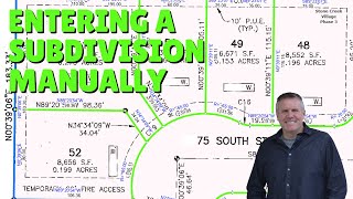
Georeferencing in ArcGIS Pro is a little different and easier than how it was done in ArcMap. Watch me demonstrate how I georeference a subdivision plat to it's boundary. Be sure to watch for the setting that draws your image correctly.
PDF to tiff geoprocessing tool idea: https://community.esri.com/ideas/1546...
Georeference PDF idea: https://community.esri.com/ideas/1741...
Go check out GPP Fitness Over 40
/ @neillindsrwndfit2898
They're good folks with a great philosophy and attitude.
Follow me socially:
Twitter / gischops
Insta / gischops
FaceBook / 2362364657392942


Recommended


