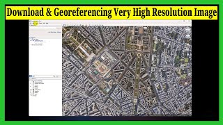
Georeferencing Map in ArcGIS || Georeference an Image or a Scanned Map using ArcMap

In this video, you can learn how to georeferencing in arcgis, georeferencing in gis, georeferencing toposheet in arcgis. This video can help you learn georeferencing in ArcGIS step by step. Feel free to like and share.
========================================
Chapters:
00:20 Download Map Image
01:00 Open ArcGIS
01:21 Set Coordinate System
04:00 Add Control Point
07:00 Verify Using Basemap
========================================
CSV to GIS Shapefile: • Excel to Shapefile in ArcGIS || Conve...
Download 10m LULC Data: • Free Download ESRI Latest Land Use La...
Study Area Map Using Shapefile: • Create Study Area Map in ArcGIS || Ma...
Download Waterbody Shapefile: • Download Water Body Data (Lakes, Rive...
========================================
Related Queries:
Georeferencing in ArcMap Tutorial
Georeferencing JPEG/JPG Image Map or Scanned Map in ArcGIS
How to Georeference an Image or a Scanned Map
How to use georeferencing map in arcgis
Georeferencing map in arcgis
georeferencing in arcgis
georeferencing in gis
georeferencing arcgis with coordinates
========================================
✨Facebook: / gisandremotesensingeducation
✨LinkedIn: / gisrseducation
#arcgis #georeferencing #georeferencing_map_in_arcgis