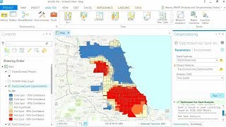
GIS Tutorial | Part 08 | Create Spatial Distribution Map | ArcGIS | Interpolation | Spatial Analysis

Shapefile Download Source: • Top 5 data sources to download spatia...
DivaGIS: https://www.divagis.org/gdata
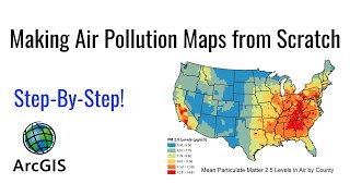
Spatial interpolation is the process of using points with known values to estimate values at other unknown points. For example, to make a precipitation (rainfall) map for your country, you will not find enough evenly spread weather stations to cover the entire region. Spatial interpolation can estimate the temperatures at locations without recorded data by using known temperature readings at nearby weather stations (see figure_temperature_map). This type of interpolated surface is often called a statistical surface. Elevation data, precipitation, snow accumulation, water table and population density are other types of data that can be computed using interpolation.