Get YouTube subscribers that watch and like your videos

Google Earth Engine 101 Part 2

PLEASE NOTE: This is the second half of a 2part training. We encourage you to watch Google Earth Engine 101 Part 1 first.
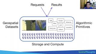
The Earth Engine API provides the ability to create your own algorithms to process raster and vector imagery. This is a twopart training geared toward people who would like to analyze satellite and vector data using the Earth Engine Javascript code editor. Part 2 of the training focuses on computing statistics on imagery, creating charts, exporting the results of your analyses.
This training was recorded at the Geo for Good Summit 2018.


![The moment we stopped understanding AI [AlexNet]](https://i.ytimg.com/vi/UZDiGooFs54/mqdefault.jpg)


Recommended