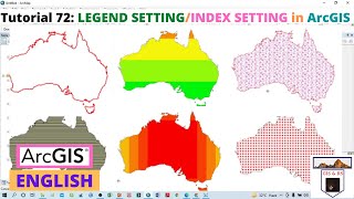
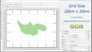
Grid setting in study area map in Arc GIS II Co-ordinate setting II Latitude and longitude Add
This tutorial gives you some easiest step to use different coordinate setting during preparation of Layout map in Arc GIS.
#how_to_introduce_lat_long_in_arcmap
#grid
#layout
#coordinatesystem
#longitudes
#latitudelongitude
#Software
#GIS
#GIS_Software
#QGIS
#QGIS
Link of Image to image georeferencing: • How to do Image to Image Georeferenci...
Link of Raster image georeferencing: https://www.youtube.com/watch?v=sf95m...
Link of Raster image digitization: https://www.youtube.com/watch?v=shnkV...
Choropleth Map Preparation using QGIS 2020: • How to prepare a Choropleth Map Prepa...
NDVI Calculation: • How to do NDVI Calculation in QGIS II...
Follow the Link for more videos:
• Video
• How to Geo Referencing of Topographic...
• How to create Thiessen Polygons in QG...
• How to merge overlapped Landsat Band...
• How to Create River and City Points M...
• How to Create Multiple Buffer Zone in...
• Change Detection Analysis of Land use...
• Change Detection Analysis of Land use...
• How to download Land use and Land cov...
• Accuracy assessment of Landuse and La...
• How to download District River, Road,...
• How to download World Shape file and ...
• How to create 3D Model of DEM image u...
• Land Use Land Cover Map of Landsat 8 ...
• How to create DEM from Google Earth I...
• How to create DEM (Elevation Map) an...
• How to create Contour line and DEM (E...
Contact: [email protected]