Groundwater potential zone mapping Using GIS and remote sensing (Part-1)

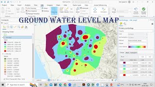
Identification of Groundwater Potential Zone and Mapping using GIS and remote sensing techniques integrated with MCA and AHP approach
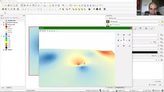
Today’s video is very vital who wants to perform using Multiple Criteria DecisionMaking analysis methods. In this video I have shown how to perform Analytic hierarchy process (AHP) techniques for mapping of Ground water potential zone and using GIS & Remote sensing techniques. I have used An AHP automatic excel sheet where you just have to put the criteria and it will automatically generate weighted score and then just input these in the ArcMap. You don’t have to calculate manually weighted score for each criterion. I have divided this video into two parts as this will be long. In the first part I will show you how to set criteria and prepare these variables and reclassify them. In the second part I’ll show you how to perform final AHP process for mapping of Ground water potential zoning. You just need to check for every map that the projection system and cell size are same. I will recommend you to set the projection system for DEM, Landsat image, study area shapefile or any file that you will use. It will save your time.
The main factors used in this video to map groundwater potential of my study area are;
1. Drainage densitycontrols runoff distribution and infiltration rates
2. Rainfall main source of water
3. Slope drives the water flow energy
4. LULC which controls the recharge process
5. Soil – determine the infiltration rate due to texture and permeability
6. Geology Infiltration movement and storage of water
You can follow through
Youtube: / @geospatialmedia1896
Facebook: / gistube101365232710125
Telegram:https://t.me/GIS_Tube
1. LULC classification using ArcGIS
• Landsat8 Supervised LULC Classificati...