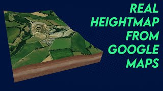
Guide: How to create high quality grayscale heightmaps for Cities: Skylines 2 | Qgis | Map Making

This tutorial teaches you, how you can make your own high quality heightmaps, in much greater details, than any online downloader can achieve. The example uses 2 m map resolution. It is important to find good, local sources for your maps. Links to a couple of sources, further down.
Q&A
Q: What's the lowest resolution you would recommend using?
A: Min. 5 meter resolution, so 5 meter or less (lower is better) for Cities: Skylines 2. If your files are in arc minutes, use this site to calculate what the resolution is in meters: https://www.opendem.info/arc2meters.html
Q: How do I see the elevation of a given point, on a map?
A: Install the plugin, called "Value Tool. You can see it working in my video, when I'm on the frontpage of QGIS. It's the lower window, in the right side. It only works on DEM data, not maps, like Google Maps, unless there's a DEM file on top, or below the geographic map. Values are in meters.
Map sources:
Iceland 2m resolution https://atlas.lmi.is/mapview/?applica...
Discord server / discord
HARDWARE (I KNOW SOMEONE WILL ASK)
Asus B650Plus WIFI
AMD Ryzen™ 9 7900 Gaming Processor
Gigabyte RTX 3060 12 GB
64GB G.Skill Trident DDR55600 CL30
Soundblaster Z
Altec Lansing speakers 5.1 (forgot the model name)
Asus PB277Q 27" monitor
Samsung 24" (+15 years old, forgot the model nuimber)
Steelseries Apex 7 keyboard
Steelseries Rival 300 mouse
~30TB of harddisk space
00:00 Introduction
00:21 Tools You Will Need
00:49 Our Goal
02:10 Getting Started
02:57 Setting Up Qgis
04:19 Downloading the World
05:38 Finding an Area of Interest
06:56 Downloading the First Map Data
11:17 Setting the Project Reference System (CRS)
14:26 Setting Up a Print Layout and Adding the Map layer
18:13 Adding Guidelines to Your Map
32:14 Adding the Local Map
39:00 Downloading Additional Map Data
45:32 Generating the Two Maps to Prepare for Export
49:19 Evaluating and Exporting the Heightmaps
58:26 Wrapup
59:06 Addendum Exporting an Image overlay
1:03:00 Rolling Credits


![HandsOn Power BI Tutorial Beginner to Pro [Full Course] ⚡](https://i.ytimg.com/vi/5X5LWcLtkzg/mqdefault.jpg)