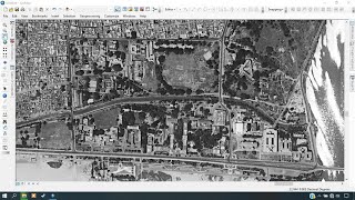
Historical high resolution satellite imagery (KH9) download | Declassified data |

High resolution satellite imagery download from USGS earth explorer.
Full playlist: • Historical Imagery processing | KH9 ...
timestamp:
0:00 Intro
0.31 Advantage of historical imagery
1:42 Imagery download from USGS earth explorer
Here are some playlists that you might be interested in:
1. Leaflet from basic to advance: • Leaflet from basic to advance
2. GeoServer with leaflet webGIS: • GeoServer and Leaflet WebGIS
3. GeoDjango project: • Bookmark note on map | GeoDjango tuto...
4. geoserverrest: • geoserverrest
5. GIS training in Nepali: • Beginner GIS training in Nepali | Arc...
6. LULC map production: • LandUse Land Cover Map production || ...
7. Geospatial analysis with python: • GeoSpatial analysis with python
8. GeoNode from basic to advance: • GeoNode from basic to Advance
9. Machine learning from the basic: • Machine Learning for geospatial data
Check out my discounted courses at the following link:
1. "Geospatial data analysis with python": https://www.udemy.com/course/geospati...
2. "Web GIS Development 2021": https://www.udemy.com/course/webgis...
3. "Web mapping and WebGIS from Dev to Deploy 2021: GeoDjango": https://www.udemy.com/course/webmapp...
4. "Introduction to Web Mapping and Web GIS 2020: GeoDjango": https://www.udemy.com/course/introduc...
5. Deep Learning Application for Earth Observation: https://www.udemy.com/course/deeplea...
6. Geospatial Data Analysis with Python: https://www.udemy.com/course/geospati...
Reference:
1. LULC map: • Land use/Land cover Change detection ...
2. LULC changes: https://www.esri.com/arcgisblog/prod...
Follow me on GitHub: https://github.com/iamtekson
Follow me on Twitter: / iamtekson
Follow me on Instagram: / iamtekson
Join Facebook group: / 1049524025731229