How is LiDAR remote sensing used for Autonomous vehicles?

Selfdriving cars are now a reality. Take a look around. Cars are already driving themselves on the roads of California, Texas, Arizona, Washington, Pennsylvania, Michigan and many more cities. Though, currently they are restricted to specific test areas and driving conditions. But how exactly do they work?
Just like humans they also face issues of traffic congestion, rash driving, potholes, trees and other obstacles on the road. But again…How do they change lane, keep a safe distance from other vehicles passing by and how do they identify roadblocks.
Let’s take a closer look at how they handle such situations smoothly?
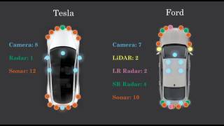
You might have noticed a rotating device installed on top of this autonomous vehicle. Sometimes these devices are mounted on the bonnet. This device is called LiDAR. It acts as the eye of selfdriving vehicles providing a 360degree view of its surroundings in order to enable safe driving.
Continuously rotating LiDAR system sends thousands of laser pulses every second. These pulses collide with the various objects around the vehicle and reflect back the signals. These light reflections are then used to create a 3D point cloud. An onboard computer records each laser’s reflection point and translates this rapidly updating point cloud… into an animated 3D representation.
#Lidar #Autonomous #gis