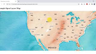
How To Add Layerswitcher Control in OpenLayers Easily

In this tutorial I will show you how you can add Layerswitcher control from olext in OpenLayers map. #layerswitcher #olext #openlayers #explorersgis
****************************************************************
You can CHECK this OUT !!
BUY Domain at Cheap Price!! : https://cutt.ly/5CEuzSD
GIS Work|| Best laptop at Low cost!!
Acer Predator Helios: https://amzn.to/3MzpjWM
ASUS TUF Gaming: https://amzn.to/3CwUpti
Lenovo Legion: https://amzn.to/3g87HEW
MSI Stealth: https://amzn.to/3CX9qWH
MSI GV15: https://amzn.to/3EHtSfM
Acer Nitro: https://amzn.to/3CBJLSh
// Buy from NewEGG
Acer Nitro at 799$ : https://cutt.ly/H2iVO0P
Asus TUF A15 at 925$: https://cutt.ly/f2iVB2T
Victus by HP 15 Gaming Laptop at 719$: https://cutt.ly/L2iBed4
****************************************************************
Best Course with Certificate at $9 only!
MS Excel Online Training : https://cutt.ly/uBx2Pc1
Introduction to spatial databases with postgis and qgis : https://cutt.ly/LBCwcXF
Survey of python for gis applications : https://cutt.ly/kBCwUKg
Python For Beginners: https://cutt.ly/ZBCJE5o
Data Science + Web Scraping, Data Analysis, Visualization with Python : https://cutt.ly/KBCLaYC
****************************************************************
Find More Tutorials:
ArcGIS Tutorial:https://cutt.ly/qWaq7gu
ArcGIS Pro Tutorials: https://cutt.ly/eMVd8bE
Qgis Tutorial: https://cutt.ly/ZWaq6e2
Other Useful Tutorials*****
Extract X, Y coordinates and Elevation Values (Z) of Point and Line features from DEM in ArcGIS: • Extract X, Y coordinates and Elevatio...
Topographic Ruggedness Index Calculation using DEM in ArcGIS and QGIS: • Topographic Ruggedness Index Calculat...
Applying Scale Factor to the Collection 2 Level 2 Surface Reflection Data and Calculate NDBI: • Applying Scale Factor to the Collecti...
Detail method to do Radiometric Atmospheric Correction of Landsat 8 Images using ArcGIS: • Video
ArcGIS Geodatabase Design Basic File Geodatabase, Field, Subtype, Domain: https://cutt.ly/JYSmgQa
Free Spatial Data |Shapefile| of Any Country & Humanitarian Data: https://cutt.ly/1WawYD1
Land Cover Data 10 m Resolution: https://cutt.ly/3Waqcvo
Least Cost Path: https://cutt.ly/xWaqmEb
Download Open street Map: https://cutt.ly/SWaqWFk
Stream Power Index SPI Calculation:https://cutt.ly/jWaqT9t
Topographic Wetness Index TWI Calculation: https://cutt.ly/qWaqIw5
Suitability Analysis Using Arcgis: https://cutt.ly/6WaqSnA
Add xy data from excel, clip, select, split, table select tools in ArcGIS: https://cutt.ly/mWaqGuS
Drainage or Stream Frequency & Infiltration number: https://cutt.ly/7WaqJ5U
Calculate Stream or Drainage Density: https://cutt.ly/VWaqX36
Extracting Stream or Drainage Network from DEM: https://cutt.ly/QWaqMS9
Detail Watershed Delineation using DEM: https://cutt.ly/TWaq3Lk
Change Detection: https://cutt.ly/sWawwfX
Download Free Shapefile:https://cutt.ly/XWawrsG
Download Soil Organic Carbon, Evapotranspiration, Land cover, Precipitation Data: https://cutt.ly/cWawtFC
Human Influence Calculation: https://cutt.ly/TWawuPv
Lineaments Extraction :https://cutt.ly/sWawi3K
World Soil Map Shapefile: https://cutt.ly/tWawaxY
Hotspot / Kernel Density Analysis: https://cutt.ly/nWawgLt
GIS Shapefile Data ( Road, Structure, etc.) for Any Country: https://cutt.ly/WWawjPq
Land Cover Change Detection: https://cutt.ly/cWawleE
Soil Moisture Index and Land Surface Temperature Calculation: https://cutt.ly/tWawzhs
Calculate normalized burn ratio (NBR): https://cutt.ly/WWawxL9
Keyword: Explore RS & GIS Tutorials, Explores RS & GIS, Explore RS and GIS, openlayers, Openlayers6,webmapping, webgis, free, opensource, vscode, openlayers for beginners, career in web mapping, webgis for professionals, web map tutorial, openlayers tutorial, openlayers production, vscode, webmaps, Layerswitcher in OpenLayers, Layerswitcher ,Layerswitcher control, olext, openlayer extensions
Contact if need
Facebook: / rsgistutorial
Twitter: / rsexplore
/ exploregisrstutorials89236a1b9