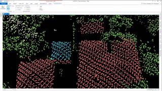
HOW TO BUILD LOD2 3D BUILDING DATA USING LIDAR POINT CLOUD DATA IN ARCGIS PRO

This video is about how to generate Level of Details 2/LoD 2 3D Building data on landscape level using LIDAR data. This workflow is very useful for the development of cities model or digital twin model.
some auxiliary info:
1. The workflow demonstrated in this video uses readytouse LIDAR point cloud data, in that the
data has already undergone all of the LIDAR preprocessing steps up to point cloud classification. If
you have raw LIDAR or preclassified LIDAR point clouds, I suggest you do the preprocessing and
point cloud classification first; there are many software programs that can do that. I also made one
video about it; just check my Agisoft Metashape Playlist.
2. I am using readytouse LIDAR data from the USGS LIDAR 3DEP Portal at this URL:
https://apps.nationalmap.gov/lidarex... the data is available for free and no registration is
needed. Highly recommended data source for learning purposes.
3. I am using ArcGIS Pro with an Advanced License and the 3D Analyst Extension for ArcGIS Pro; if
you don't have these prerequisites, I am afraid you wouldn't be able to practice the workflow I
demonstrated in this video.
music : bensound.com
#arcgispro #lidar #3dbuilding