How to Calculate Erosion u0026 Accretion of a River for different time period in ArcGIS

Hello everyone,
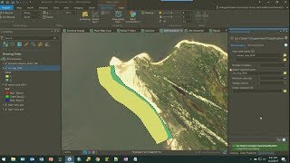
Welcome to GIS & RS Solution channel. Hope you are fine with your friends and family. Today’s tutorial is about how to calculate erosion and accretion of a river. I will show and explain you step by step guideline like convert raster to polygon, extract river, area calculation, intersect between present year and previous year, erosion and accretion calculation, export data to excel and analysis in excel, make graph and figure, prepare map layout showing unchanged area, erosion and accretion area of different time period and finally export map. Hope this going to be very helpful for you.
Download Landsat Image: • How to Download Satellite Image Lands...
Land use and Land Cover map (Supervised): • Supervised Image Classification | Lan...
Land use and Land Cover map (Unsupervised): • Unsupervised Classification | Land Co...
How to Cut/Extract Study Area/AOI from Satellite Image and Shapefile: • How to Cut/Extract Study Area/AOI fro...
#erosion_accretion #calculate_river_erosion_accretion #arcgis #gis