Rock YouTube channel with real views, likes and subscribers

How to Calculate NDVI using ArcGIS || Normalized Difference Vegetation Index

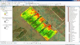
The normalized difference vegetation index (NDVI), which is derived from remotesensing (satellite) data, is closely linked to drought conditions. To determine the density of green on a patch of land, the distinct colors (wavelengths) of visible and nearinfrared sunlight reflected by the plants are observed.
The NDVI index detects and quantifies the presence of live green vegetation using this reflected light in the visible and nearinfrared bands. Put simply, NDVI is an indicator of the vegetation greenness —the density and health—of each pixel in a satellite image.
#NDVI
#Arcgis
#Normalized_Difference_Vegetation_Index
#Calculate


Recommended