Secret weapon how to promote your YouTube channel

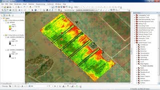
How to calculate NDVI with ArcMap 10.1

In this video I use ArcMap 10.1 with a 4 band Aerial Photo (RGBiR) to calculate the Normalized Difference Vegetation Index (NDVI), a graphical indicator that can be used to analyze remote sensing measurements to assess whether the target being observed contains live green vegetation or not. I use Spatial Analyst extension along with Raster Calculator in the Map Algebra Toolbox.


Recommended