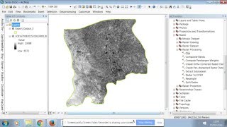
How to clip Landsat Image on ArcGis

HOW TO CUT A RASTER IMAGE IN ARCGIS
Usage :
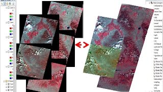
This tool allows you to extract a portion of a raster dataset based on a template extent. The clip output includes any pixels that intersect the template extent. If you want to extract a portion of a feature dataset, use the Clip tool found in the Analysis toolbox.
The clipped area is specified either by a rectangular envelope using minimum and maximum x and ycoordinates or by using an output extent file. If the clip extent specified is not aligned with the input raster dataset, this tool makes sure that the proper alignment is used. This may cause the output to have a slightly different extent than specified in the tool.
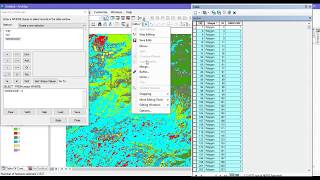
An existing raster or vector layer can be used as the clip extent. If you are using a feature class as the output extent, you have the option to clip the raster by the minimum bounding rectangle of the feature class or by the polygon geometry of the features. If clipping geometry is used, then the pixel depth of the output may be promoted. Therefore, you need to make sure that the output format can support the proper pixel depth.
When using ArcMap, you also have the ability to use the selected features as the clipping extent. If a feature within the feature class is selected and Selection Extent is checked (clipping_geometry is set to ClippingGeometry), then the output clips out the areas that are selected. If a feature within the feature class is selected but Selection Extent is not checked, then the output clips out the minimum bounding rectangle for that feature.
You can save your output to BIL, BIP, BMP, BSQ, DAT, Esri Grid, GIF, IMG, JPEG, JPEG 2000, PNG, TIFF, or any geodatabase raster dataset.
The extent values must be in the same spatial coordinates and units as the raster dataset.