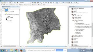
how to clip raster imagery in arcgis

In this tutorial, i willpresent how to clip raster imagery in arcgis
Why clip rasters?
Clipping rasters means that you can save time. Processing data to a larger extent can really put a crunch on you and your processor.
You can clip and display specific portions of a raster image in a drawing with a clipping boundary.
With a clipping boundary, only the parts of the image that you want visible are displayed. You can define the part of an image that you want to display and plot by clipping the image with IMAGECLIP. The clipping boundary can be a polyline, rectangle, or a polygon with vertices within the boundaries of the image. You can change the boundary of a clipped image. You can also delete the clipped boundary of an image. When you delete a clipping boundary, the original image is displayed.
#clip
#arcmap
#arcgistutorial
#arcgis
#gis
#remotesensing
#satellitedata
#raster