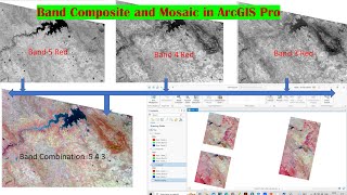
How to Composite Band in ERDAS | How to composite image in ERDAS || Layer Stacking in ERDAS

Image Composites:
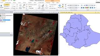
As a remote sensing study we are using Spectral Band Image in this practice we do each band of a multispectral image that can be displayed one band at a time as a grayscale image, or as a combination of three bands at a time as a color composite image. The three primary colors of light are red, green, and blue (RGB). Computer screens can display an image composed of three different bands, by using a different primary color for each band. When we combine these three images, the result is a color image with each pixel’s color determined by the combination of RGB of different brightness.
ERDAS Tutorial For You:
1) How to Create Band Composite Image in ERDAS Imagine: • How to Create Band Composite Image in...
2) How to Create Spectral Signature in ERDAS Imagine: • How to Create Spectral Signature in E...
3)How to Create Supervised Classification using ERDAS: • How to Create Supervise Classificatio...
4)How to Create Mosaic in ERDAS: • How to Create Mosaic in ERDAS || How ...
5)How to create subset in erdas imagine: • How to create subset in erdas imagine...
6)How to use Erdas Imagine software: • How to use Erdas Imagine software || ...
7) Install ERDAS Imaging: • Video
8)How to Give Universal Reference in ERDAS: • How to Give Universal Reference in ER...
9)How to Composite Band in ERDAS: • How to Composite Band in ERDAS | How ...
10)How to borrowing licensing ERDAS Imagine: • Video
11)How to make PAN Sharping Image in ERDAS: • How to make PAN Sharping Image in ERD...
12)How to create Unsupervised classification using ERDAS : • How to create Unsupervised classifica...
Offical websites For You:
1) ESRI: https://www.esri.com/enus/home
2) ArcMap: https://desktop.arcgis.com/en/arcmap/
3) ArcGIS : https://www.esri.com/enus/arcgis/abo...
4) QGIS : https://www.qgis.org/en/site/
5) ERDAS IMAGINE: https://www.hexagongeospatial.com/pro...
6) ENVI : https://www.l3harrisgeospatial.com/So...
7) ArcScan: https://desktop.arcgis.com/en/arcmap/...
8) G2: https://www.g2.com/categories/gis
9) MapInfo Professional (Precisely): https://www.precisely.com/product/pre...
How to Download Vector Data Offical sites:
1)Sogefi: http://www.sogefisig.com/ressources/
2)statsilk: http://www.statsilk.com/maps/download...
3)Diva: http://www.divagis.org/gdata
Need Any Help Contact Us:
♦ My Parsonal Fb id : https://tinyurl.com/59ted3un
♦ Facebook Page : https://tinyurl.com/854wdr4r
♦ Email: [email protected]
♦ +918888880624
♦ Mail: [email protected]
♦ What'sapp: 8888880624
Share, Support, Subscribe!!!
Youtube: http://www.youtube.com/c/DoITNew?sub_...
#erdas #bandcombination #Layerstacking #ArcGIS #ENVI #FCC #RemoteSensing#QGIS