How to Composite Bands and AOI Extraction from Satellite Imagery in ArcGIS || ArcGIS Tutorial

In this tutorial you'll learn "How to Composite Bands and AOI Extraction from Satellite Imagery in ArcGIS", Just follow the step by step.
Step by Step Works:
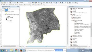
After Downloading Satellite Images, it need to extract you can use WinRAR or 7zip. Then Open ArcMap and add the raster data. Now we need to join all the bands for further analysis.
➡ Go to ArcToolbox ▶ Data Management Tools ▶ Raster ▶ Raster Processing ▶ Composite Bands.
Select and add all bands. Next choose a output directory to save the composite image and click ok.
Area of Interest Extraction:
After that, Go to ArcToolbox ▶ Spatial Analyst Tools ▶ Extraction ▶ Extract by Mask.
Input the composite image to Input raster and the shapefile to feature mask data and click ok.
Supervised Image Classification: • Supervised Image Classification in Ar...
Chapters:
00:00 Band Composition
03:24 AOI Extraction
#arcgis #landsat #remotesensing


![The moment we stopped understanding AI [AlexNet]](https://i.ytimg.com/vi/UZDiGooFs54/mqdefault.jpg)