How to create a flood simulation in ArcGIS | Create animation in ArcScene

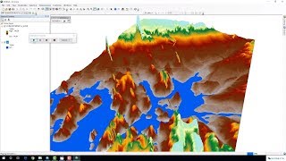
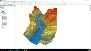
This video will help you to create flood simulation model in ArcGIS. We used two ArcGIS software here. Arcmap and ArcScene. By using the ArcMap we created a shapefile and georeferenced our aerial image. Then in ArcScene we work with the 3D model. And create a time series that was the simulation model of flood. So, creating this tutorial was so fun. Hope you will also like this to create animation by using ArcGIS.
To download the data watch this video: • Download data for GIS specially Lands...
Download satellite image: / watch
v=qntkffZgDSc&t=45s
Download shapefile data GIS: • How to download shapefile data GIS fo...
Subscribe to My channel for NEW VIDEOS EVERY DAY and make sure to enable Push Notifications so you'll never miss a new video.
All you need to do is PRESS THE BELL ICON next to the Subscribe button!
Learn ArcGIS software in this lecture series...
Check my Fiverr profile: https://www.fiverr.com/abir3434
Add me on Facebook https://facebook.com/profile.php?id=1...
Follow me on Instagram / kazialmuqtadir
Related Tags: how to create a flood simulation in arcgis,Create animation in ArcScene,flood mapping using arcgis,arcgis flood simulation,arcgis flood mapping,animation in arcgis,animation in arcscene,arcscene animation tutorial,facebook,youtube,flood 3d,Arcgis,ArcScene,3d analyst,3D animation in gis,3D model in GIS,arcgis flood model,flood gis,flood analysis arcgis,gis software free download,how to use arcscene,how to make a flood map,animation in arcscene,flood simulation software,Kazi Almuqtadir,gis,remote sensing,
#kazi_almuqtadir #arcgis #gis