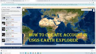
How To Create Account in USGS Earth Explorer For Downloading Free Satellite Images

You will learn how to create an account in USGS EarthExplorer for free in this video. I hope this video will help you to enhance your knowledge in GIS and Remote Sensing even more. To assess land cover changes, land use changes, climate change analysis, environmental modelling, ecosystem modelling, vegetation changes, and Land Surface Temperature (LST) satellite images are very essential and this video will help you to create an account in USGS EarthExplorer so that you can download the satellite images for free. Through this video you will easily be able to log in to the USGS Earth Explorer website and then you can easily download numerous satellite images yourself.
Link: https://www.usgs.gov
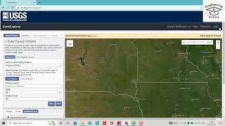
The EarthExplorer (EE) user interface, created by the United States Geological Survey (USGS), allows for online searching, browsing, metadata export, and data download of satellite, airplane, and other remote sensing inventory. NASA LP DAAC Collections in EE include MODIS land data products from both the NASA Terra and Aqua missions, AST_L1T and ASTER GDEM data products obtained from the NASA ASTER mission, NASA MEaSUREs products, ASTER Global Emissivity Datasets, VIIRS data products obtained from the NOAA/NASA joint Suomi National PolarOrbiting Partnership (Suomi NPP) satellite, and ECOSTRESS products. Freely available satellite data provide a unique resource for people who work in agriculture, geology, forestry, regional planning, education, mapping, and global change research.
For more videos related to GIS, Remote Sensing, Geoinformation Science and Climate change please watch videos of @EARTHGISensing . @EARTHGISensing will help you throughout your journey to learn all the tools and techniques of remote sensing and GIS.
I hope you like the videos of @EARTHGISensing. If so, please do not forget to like, comment and subscribe to the channel.
#createanaccountinearthexplorer #loginfordownloadinglandsatimages #signupforfreesatelliteimages #registerinearthexplorer #remotesensing #earthexplorer #satelliteimages #usgsearthexplorer #registrationusgs #earthexplorerusgs #usgs