How to create boundary line shapefile from raster Image II Retrieve raster image to boundary polygon

#CreateBoundary, #CreateAdministrativeArea,#CreateDistrictBoundary
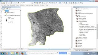
In this tutorial I will show how to create boundary line shapefile from raster Images, Retrieve raster image boundary as polygon shapefile, From this tutorial you can learn how to get boundary of raster image as polygon in ArcMap
Others necessary Tutorial:
How to create stream order and Drainage density map in ArcGIS: • How to create stream order and Draina...
How to download shapefile data GIS for any country: • How to download shapefile data GIS fo...
How to Create DEM from Google Earth: • How to Create DEM from Google Earth
How To Import GIS Shapefiles in Google Earth Pro: • How To Import GIS Shapefiles in Googl...
Relevant Tags:
Extract polylines from JPG image of district boundary map in ArcGIS,
Create boundary line shapefile from raster Images,
Raster data to boundary line,
Dissolve,clip,boundary line, clip from raster data,
Boundary line from DEM,
Digital Elevation model to polygon,
Retrieve raster image boundary as polygon shapefile,
Clip Raster with shapefile boundary,
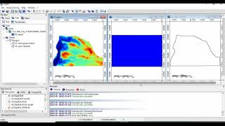
How to reclassify dem,
reclassify raster image,
reclassify raster data,Getting boundary of raster image as polygon in ArcMap
If you will like my video the just hit the like button and
#PleaseSubscribe & #ShareEliteandAfana you tube Channel to your community