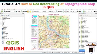
How to create DEM MAP in QGIS
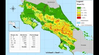
This tutorial gives a wide idea about the preparation of digital elevation map using DEM image. This tutorial also shows a stepbystep procedure for preparing contour mapping from the DEM Image. It is an important Gis technique for analysis of different planning and development processes.
#DeM
#conturemapping
#Software
#GIS
#GIS_Software
#QGIS
Link of Image to image georeferencing: • How to do Image to Image Georeferenci...
Link of Raster image georeferencing: https://www.youtube.com/watch?v=sf95m...
Link of Raster image digitization: https://www.youtube.com/watch?v=shnkV...
Choropleth Map Preparation using QGIS 2020: • How to prepare a Choropleth Map Prepa...
NDVI Calculation: • How to do NDVI Calculation in QGIS II...